

In the final hours before deadly Hurricane Helene made landfall last week, research teams from the University of Florida scrambled up Florida’s west coast in a two-day blitz to set up storm-monitoring equipment that will provide valuable insights into environmental, structural and human survival.
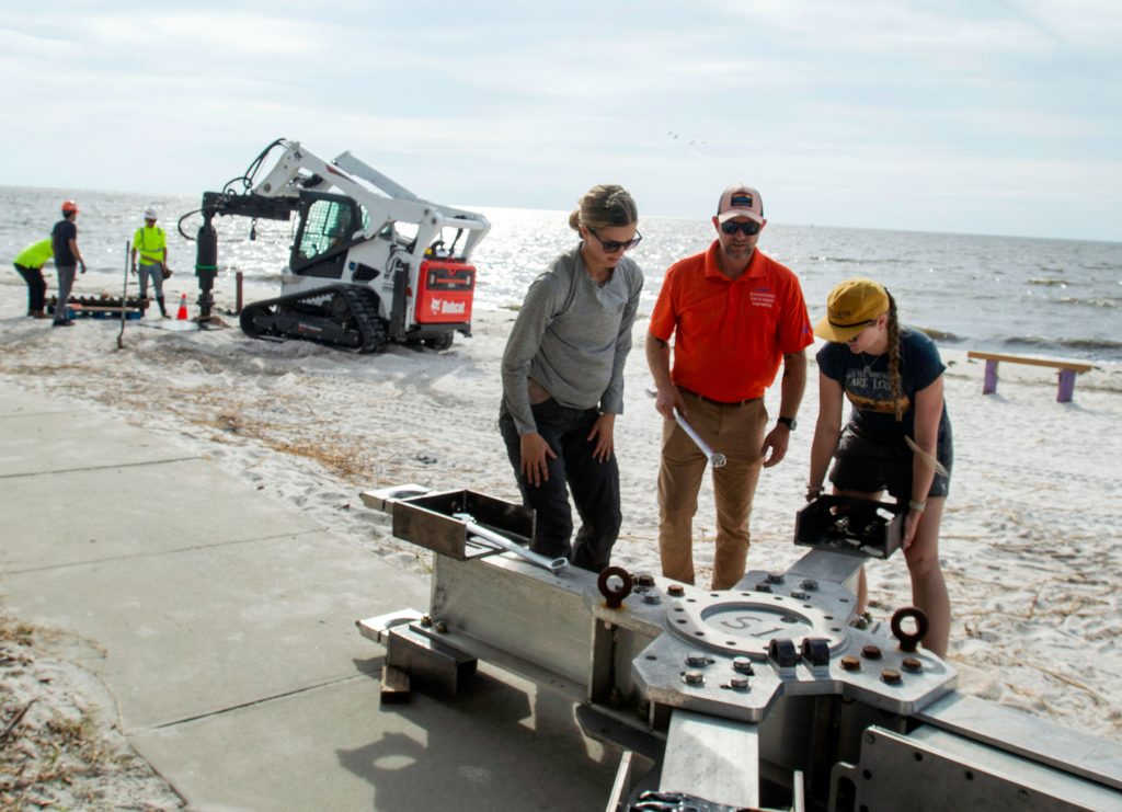
On Sept. 25 — the day before Helene slammed into the Big Bend — about a dozen UF faculty members, staff and graduate students from the Herbert Wertheim College of Engineering arrived at Cedar Key’s beach to install a UF-developed storm-monitoring tower called a Sentinel. These 33-foot-tall devices collect data on wind, storm surge, waves, and water quality before, during and after a hurricane makes landfall.
It reports data back to researchers in real time. The goal is to analyze the data collected on wind, surge and water impacts that could be used to mitigate coastal damage, property damage and structural vulnerabilities that could endanger life.
This was the Sentinels’ first full deployment — a “landmark moment,” noted College of Engineering Interim Dean Forrest Masters, who helped launch the program and design the Sentinels.
“This is a first-of-its-kind monitoring station developed by civil, coastal and environmental engineers in our program to measure the dangerous effects of wind, storm surge, and waves on civil infrastructure,” Masters said from Cedar Key.
As that team was erecting the Sentinel, another UF-led team was spreading out across Cedar Key, Horseshoe Beach, and Suwannee to place wave gages, water-pressure sensors, and an Acoustic Doppler Current Profiler to measure water levels, waves, and the pace of the water. The team also used Light Detection and Ranging (LiDAR) systems and drones to document detailed pre-storm conditions.
Nina Stark, an associate professor with UF’s Department of Civil & Coastal Engineering, led a team of NSF-funded Nearshore Extreme Events Reconnaissance (NEER) association and collaborated with the NSF-funded Natural Hazards Engineering Research Infrastructure (NHERI) RAPID facility team on before- and during-storm data collection.
Both UF teams wrapped up in Cedar Key around noon on Sept. 25. The Sentinel team then hustled up the coast to deploy a second tower on Mashes Sands Beach in Panacea, very close to where Helene’s eye was expected to hit the following day.
They arrived back in Gainesville that evening, and about a dozen Hurricane Research team members hit the road again at 5 a.m. Thursday — storm day — to install two portable wind towers, one at Taylor Correctional Institution in Taylor County, the other off U.S. 98 in Wakulla County.
UF researchers have used the wind towers during earlier storms, placing them as close to the storm’s track as possible before the conditions become unsafe. The towers are designed for inland measurements, while Sentinels are designed for wind, water, floods and other severe coastal conditions; they can withstand about 16 feet of storm surge.
The team placed the inland wind towers as close to the storm’s track as possible before the conditions became unsafe. They made it back safely, returning to Gainesville just as Helene hit Perry.
“The Sentinel at Cedar Key provided a critical live data stream,” said Brian Phillips, Ph.D., the project lead and an associate professor with the Department of Civil & Coastal Engineering. “We were watching it as the storm approached and made landfall. NOAA [National Oceanic and Atmospheric Administration] had access to it and quoted our wind-speed measurements on the official updates. It made an immediate impact.”
When the teams returned to collect the equipment, the neighborhoods were very different.
“Ultimately, the data will be used to help reduce the loss of life and property during extreme wind events.”
Brian Phillips, professor and Sentinel project lead
“While all our instruments were in surprisingly good shape, the devastation around us and in the communities was severe,” Stark said. “Multiple buildings and infrastructure systems located near our instruments were fully or partially destroyed. One instrument could not be accessed because the road to Shired Island [in Dixie County] was washed out.”
Phillips’ team recovered the Sentinels on Sunday, noting there was little structural damage in Mashes Sands Beach.
“Cedar Key was a different story,” Phillips said. “Police were restricting access. It seemed every house was affected. The contents of many houses were water damaged and moved to the curb for disposal. There were piles of debris on the dock being loaded onto trucks.”
Now UF researchers are sifting through the results.
“The Sentinels gave us important data. They survived structurally and performed exactly to our expectations,” Phillips said, noting this is the first time UF researchers have collocated wind and storm surge data together at the point of landfall.
“Now we can see how much wind is contributing to the surge and how the waves are affecting the wind measurements. There is an interaction between the wind and waves, and now we have a lot more data with a better understanding,” he added. “We’re very excited to see what kind of data we will get with this because it will help us to interpret the observed damage. Ultimately, the data will be used to help reduce the loss of life and property during extreme wind events.”
Stark also was pleased with the performance of her equipment, noting all but one of the devices provided data.
“At some locations in Cedar Key, even further back along [State Road] 24, we saw water levels at 3.5 meters above what low tide would be,” she said. “These are very severe heights.”
Stark’s data collection before, during and after the storm looks at coastal damages, failures and impacts, and the processes leading to those; they can provide data on erosion around building foundations, for example.
“I am very interested in soil processes – I am in the geo-systems program. I am interested in how soil, seabed and coastal sediments move. I am interested in erosion hotspots,” she said. “We’re also looking at where sediments and debris pile up. In some of these events, we see debris smashed around. Significant erosion, soil failure, and accumulation events destroy infrastructure and the built environment.”
Meanwhile, Phillips’ team is applying the Sentinel and tower data to points inland. The best use of their data will be in storm preparedness; before people pick sunny spots and build structures on the coast, they need to know the risks of storm surge. Data UF collected from Helene helps researchers know what loads buildings can withstand in specific locations.
“We now have full-scale field data on surge, waves and wind, a step toward simulating and re-creating these hazards in numerical models and in laboratory experiments,” Phillips said.
The Sentinel placement was a personal victory for Masters, who, prior to becoming interim dean, was knee-deep in coastal, wind and storm-mitigation research. The Sentinels started with his vision, and he watched the first installation last week like a proud papa.
“After years of preparation and hard work, watching this project come to life, collecting valuable data in real time, is a huge milestone for all of us,” Masters said. “It’s more than just research — it’s a culmination of passion and our strong desire to understand hurricanes better to make coastal communities more resilient to wind and water hazards.”