Module 3: What are the types of satellite and space telescope data?
This will look like learning about the kinds of data that satellites and space telescopes collect. Understanding the kinds of data and format of the data collected by satellites and space telescopes will help you understand how they can be used by AI systems to make predictions or solve for questions we have about Earth and Space.
Module 3 – Middle School
Part 1 – Satellite and Telescope Data
Part 2 – Designing a FAQ sheet for a Satellite or Space Telescope
Part 1 – Satellite and Telescope Data
Satellites
What is a Satellite?
Satellites are things that orbit (revolve around) something else in space. Earth is a satellite around the sun and the moon is a satellite that orbits the earth. Humans can make man-made satellites that can go up into space and orbit a planet or plants to collect information we want to know. Orbits are the regular repeating pattern that the satellites takes around the object.
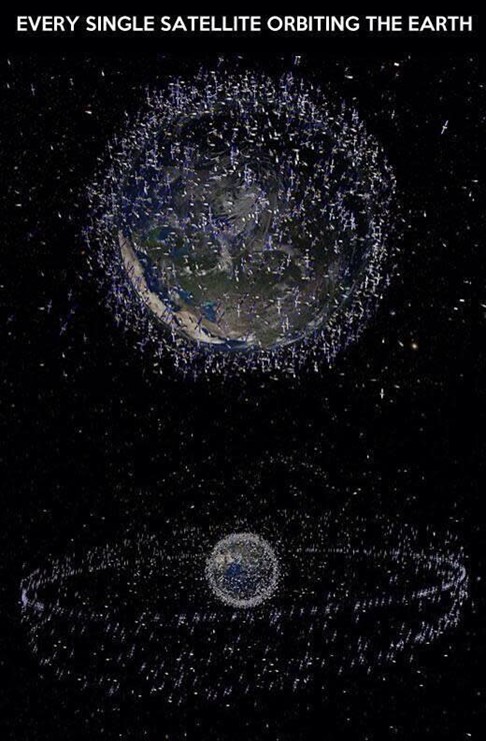
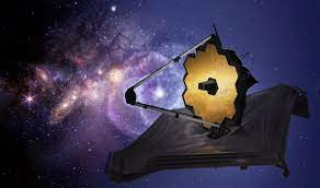
Image 1: Satellites Orbiting the Earth from Yahoo News.
There are thousands of satellites that orbit the Earth that can be seen in Image 1. Many of them are no longer used, but since they are in orbit, they just stay up there as space junk. Many of them are still working and collect data for use by governments or companies.
Satellites collect all kinds of data for use including pictures of the planet or things in space, using sensors to collect information. Some Satellites are used for communication such as phone calls, TV or internet. One main use that is well know is for GPS. GPS stands for Global Positioning Satellites and there are more that 20 GPS satellites positioned around the Earth that help provide location data.
Why Satellites are used for imaging other objects in space
Satellites can be better than Earth based telescopes to image things in space. Telescopes on Earth have to look through the atmosphere and that can create blurry or poor images owing to dust, clouds, and other atmospheric events.
What makes a Satellite a Satellite?
Aside from the fact that satellites have to orbit, all satellites share some common parts – Power Supplies and Antennas. Satellites can also carry multiple sensors and probes that collect information.
Power Supplies are used to power the thrusters or small motors that keep the satellite in orbit, and to power the antenna, sensors and probes. Older satellites had very expensive batteries, but now many satellites have solar power to help recharge the batteries on the satellite.
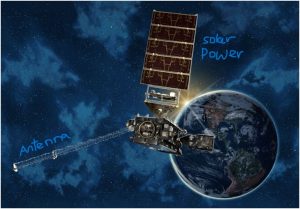
Image of the Goes Satellite with the antenna and solar power source labeled. Image from NASA
How Satellites Stay in Orbit
Satellites stay in orbit by moving at a speed that just balances the force of gravity trying to pull them back to Earth. When satellites are launched, they are sent at speeds large enough to get them above the Earth’s atmosphere. Once they are at the right height, the rocket lets the satellite go, and the speed at which it is released holds it into it’s orbit. Some satellites can stay in orbit for over 100 years as long as they do not need to use too much energy to maintain their speed and they avoid collisions with other satellites or space junk.
Watch this video on how they stay in orbit.
GPS Satellites
The name for the system of 31 satellites that orbit the Earth and make up the GPS system is called NAVSTAR. These satellites are located 12,000 miles above the Earth and travel about 7,000 miles per hour. These satellites are powered by solar power and weigh about 2000 pounds and are designed to last about ten years.
To Learn how GPS works watch this video from NASA
Weather Satellites
Weather satellites have a lot of sensors and probes they use to monitor the weather on the Earth. These can include things that measure different weather conditions, Ozone and other gases and atmospheric events.
Watch this video on how these work.
Here is a link to a longer video if you want to watch and learn more.
Sensors and Data on Weather Satellites
Many weather satellites are positioned above the equator so that they rotate the Earth once a day. Since this is the same amount of time the Earth rotates and the satellites rotate in the same direction as the earth, the satellites seem to be parked in the same spot over the Earth and are called geostationary satellites.
The Satellites take a variety of data that gets sent back to computers on Earth. The main ones are pictures of the Earth which you may have seen on websites, news or TV. The geostationary satellites can take pictures of the same spot during the day to show successive changes to the weather. There are also satellites parked over poles of the Earth, and they can provide better detailed images, but they do not take images as frequently or of the exact same location on the Earth. The pictures that are taken are stored in a format called Tag Image File Format (.tiff). You may be familiar with .jpg which is how may phones take images. Tiff images are generally large images (in terms of bytes), but keep image data information as they are transferred to the Earth. Below is one of the first complete images of the Earth’s weather taken by a satellite in 1965.

Other sensors that are used are infrared or heat energy given off by things like Earth’s surfaces for water, clouds and land. The intensity of the infrared image is related to the temperature of the object. The intensity of the infrared images create a “heat map” of the surface. The images below were taken of Yellowstone National Park in 2021.
In the visible image, red-green-blue colors are used to simulate natural color on the Earth. In thermal infrared image, bright pixels are warmer temperatures for the surface, and dark pixels are cooler temperatures. The white spots are clouds over the park, and the dark blot in the middle is a big lake. These images are created in a file type called jpg or GeoTiFF which is a type of a TIFF Image. Jpg images are just the picture like on your camera, but GeoTIFF images carry information about the geographic location of the image which can be opened in programs like geographic information systems (GIS).
There are other satellites like OCO-2, https://climatekids.nasa.gov/mission-oco-2/ , which are lower to the Earth and monitor CO2 emissions and the carbon cycle. They have special sensors to record this information.
Module 3 Part 1- Satellite and Telescope Data
Complete the two activities related to Satellites and how they collect images and upload them to the Qualtrics portal based on activities from Project ATMOSPHERE, an initiative of the American Meteorological Society 2012. Make sure when you upload your files, that you rename them as “Module 3 Part 1 Team name. Save as a PDF or work doc. Do not send pictures or HEIC files. You can print out the documents, fill them out and then scan and attach as a PDF.
Part 2 – Designing a FAQ sheet for a Satellite or Space Telescope
For this part of the contest, you will create a FAQ sheet on ONE satellite or space telescope so find one you really want to know more about. FAQ sheets contain information most people would want to know. In this case, we want to know more about the satellite or telescope.
See this template for all the information you will need to have, but be creative! Your FAQ sheet can be made in Canva, Adobe, Google or Word, you can add color or additional information, but the key information has to be in the document. You also have to cite/reference your sources properly. For more on that see this document.
How to find a Satellite or space telescope
OSCAR has a database of all satellites currently in orbit
https://space.oscar.wmo.int/satellites
Wikipedia has a list of currently operating satellites – https://en.wikipedia.org/wiki/List_of_Earth_observation_satellites
NOAA has a list of currently satellites they operate or work with
https://www.nesdis.noaa.gov/our-satellites/currently-flying
Go Astronomy has a list of space telescopes as of 2024
https://www.go-astronomy.com/observatories-space.php
The US Space Force has a list of all their space satellites
https://www.spaceforce.mil/About-Us/Fact-Sheets/
Resources and References
https://spaceplace.nasa.gov/satellite/en/
https://www.garmin.com/en-US/aboutgps/
https://www.nesdis.noaa.gov/news/why-dont-satellites-fall-out-of-the-sky
https://explorer1.jpl.nasa.gov/galleries/earth-from-space/
https://www.usgs.gov/observatories/yvo/news/step-step-guide-accessing-satellite-images-yellowstone
https://climatekids.nasa.gov/mission-oco-2/
https://imagine.gsfc.nasa.gov/observatories/data/data_ground.html